Search
26 Jan 2026
Search
26 Jan 2026
Please allow ads as they help fund our trusted local news content.
Kindly add us to your ad blocker whitelist.
If you want further access to Ireland's best local journalism, consider contributing and/or subscribing to our free daily Newsletter .
Support our mission and join our community now.
To continue reading this article, you can subscribe for as little as €0.50 per week which will also give you access to all of our premium content and archived articles!
Alternatively, you can pay €0.50 per article, capped at €1 per day.
Thank you for supporting Ireland's best local journalism!


Storm Chandra is forecast to bring gusts of up to 70 mph (112kmh) to parts of the island of Ireland this week, as several counties fall under weather warnings.
Chandra could see power outages, falls of snow, and some communities cut off by flooded roads.
The UK Met Office said Chandra will bring “very strong winds” to Northern Ireland as it advised the public to expect longer journey times and likely cancellations on road, rail, air and ferry services.
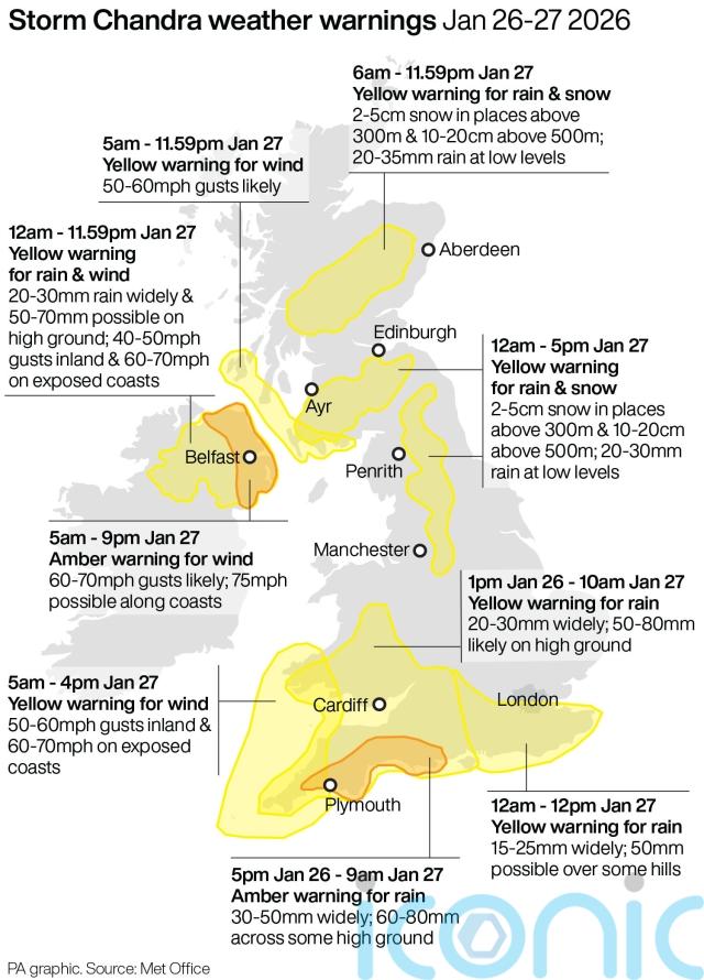
The storm has the potential to damage buildings, with flying roof tiles and other debris posing a danger to life.
It said there is a “good chance that power cuts may occur” which could affect other services such as mobile phone coverage.
Forecasters also warned that some communities may be cut off by flooded roads, with outbreaks of rain spreading across Northern Ireland during Tuesday, potentially even falling as snow for a time on the highest ground.
Tuesday's 4cast is very wet and windy, with #StormChandra set to bring heavy rain to many, with snow and damaging winds in places ⚠️ pic.twitter.com/sqgMBOtgX3
— Met Office (@metoffice) January 26, 2026
Northern Ireland’s Education Authority said on Monday afternoon that there were no plans to issue general school closure notices, but that local school leaders should assess conditions in their areas and make their own decision if required.
The Met Office said rainfall totals of 20-30mm are “likely fairly widely”, with 50-70 mm possible on high ground especially in eastern areas.
A status yellow warning for rain was in place from midday until midnight on Monday for a region affecting five counties in Northern Ireland but excluding Antrim and those closest to the northern coast in Londonderry.
#StormChandra will bring severe gales to some areas on Tuesday with the strongest winds in the west ⚠️
Winds will often come from a more unusual southeasterly or easterly direction, so places usually sheltered will bear the brunt of the winds. Here's what to expect 👇 pic.twitter.com/SDWhIlJT04
— Met Office (@metoffice) January 26, 2026
The Met Office said: “A spell of heavy rain will move north-eastwards across Northern Ireland during Monday afternoon, 10-20mm of rain is expected to fall widely with 20-30 mm in a few areas and as much as 40 mm over high ground.”
This was immediately followed by a status yellow warning for wind and rain for all of Northern Ireland for all of Tuesday.
A separate amber warning for wind is in place for the north and east of the region between 5am and 9pm on Tuesday.
NI Water said that Silent Valley Mountain Park will be closed all day on Tuesday.
Update⬇️⚠️Yellow wind warning was issued for Ireland on Tues 27/01 in association with #stormchandra
❗️Rain falling on already saturated ground will lead to localised impacts❗️Winds will be very strong & gusty particularly on the coasts & exposed areashttps://t.co/t2JoveRUyC pic.twitter.com/8pcumSM7eC
— Met Éireann (@MetEireann) January 26, 2026
In the Republic of Ireland, Met Eireann has issued a yellow-level warning for Rain in Carlow, Kilkenny, Louth, Wexford, Wicklow, and Waterford between midnight and 11pm on Tuesday.
There is also a yellow-level warning for wind for the Republic of Ireland between 3am and 11pm on the same day.
Meteorologist Rebecca Cantwell said Chandra will bring “heavy spells of rain with strong winds, especially along the coast”.
With rain falling on already saturated ground and many rivers approaching or exceeding bank-full conditions, Ms Cantwell said localised flooding is expected.
Met Eireann said its warnings are likely to be updated.

Subscribe or register today to discover more from DonegalLive.ie
Buy the e-paper of the Donegal Democrat, Donegal People's Press, Donegal Post and Inish Times here for instant access to Donegal's premier news titles.
Keep up with the latest news from Donegal with our daily newsletter featuring the most important stories of the day delivered to your inbox every evening at 5pm.
Follow us on


This publication supports the work of the Press Council of Ireland and Office of the Press Ombudsman, and our staff operate within the Code of Practice of the Press Council. You can obtain a copy of the Code, or contact the Council, at www.presscouncil.ie, Lo-call 1800 208 080 or email: info@presscouncil.ie.


